Its
the third of October 2002; and along the hurricane-prone coast of
Louisiana people await Lili, as a hurricane, one of nature's most
violent and devastating phenomenon.
The National Hurricane Centre reports:
"LILI REMAINS AN EXTREMELY DANGEROUS CATEGORY 4 HURRICANE; DEADLY 10 TO
20 FOOT STORM SURGE APPROACHING THE GULF COAST;
NOAA Warns Final Preparations to Protect Life and Property Should Be
Rushed to Completion Now; Follow Advice from Local Emergency Managers".
Lili is
not the first hurricane of this year. Actually last week its
predecessor Isidore made landfall at about the same place
Lili is expected to. The city of New Orleans together with a large
coastal area suffered from severe flooding. At the moment the mess
isn't cleared away yet, but Lili certainly won't care about that.
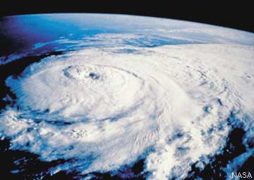
What's a
hurricane?
A hurricane is a type
of tropical cyclone, which is a generic term for a low pressure system
that generally forms in the tropics. The cyclone is accompanied by
thunderstorms and, in the Northern Hemisphere, a counter clockwise
circulation of winds near the earth's surface.
Tropical cyclones with maximum sustained surface winds of less than 39
mph are called "tropical depressions".
Once the tropical cyclone reaches winds of at least 39 mph they are
typically called a "tropical storm" and assigned a name.
If winds reach 74 mph, then they are called: a "hurricane" in the North
Atlantic Ocean, the Northeast Pacific Ocean east of the dateline, or
the South Pacific Ocean east of 160E. In the Northwest Pacific Ocean
west of the dateline the cyclone is called "typhoon".
How and where do these monsters develop?
A
tropical cyclone needs several ingredients and conditions to develop.
- Warm ocean waters (of at least
80°F) throughout a sufficient depth (unknown how deep, but at least on
the order of 150 ft). Warm waters are necessary to fuel the heat engine
of the tropical cyclone.
- An unsettled atmosphere which
cools fast enough with height. In such an atmosphere thunderstorm
easily develop and it's the thunderstorm activity which allows the heat
stored in the ocean waters to be liberated for the tropical cyclone
development.
- A minimum distance of at least
500 km [300 mi] from the equator. This has to do with the pressure the
turning earth brings to bear upon the atmosphere. For the birth of a
tropical cyclone, there is a requirement for certain amounts of this
pressure.
- Tropical cyclones cannot be
generated spontaneously. To develop, they require a weakly organized
system with sizable spin and low level inflow.
- Low values (less than about 23
mph) of vertical wind shear between the surface and the higher
altitudes of the atmosphere. Vertical wind shear is the magnitude of
wind change with height. Large values of vertical wind shear disrupt
the incipient tropical cyclone and can prevent genesis, or, if a
tropical cyclone has already formed, large vertical shear can weaken or
destroy the tropical cyclone by interfering with the organization of
deep convection around the cyclone centre.
To be short the ingredients for a hurricane include a
pre-existing weather disturbance, warm tropical oceans, moisture, and
relatively light winds aloft. If the right conditions persist long
enough, they can combine to produce the violent winds, incredible
waves, torrential rains, and floods we associate with this devastating
monster from nature; that threatens many lives over and over again.
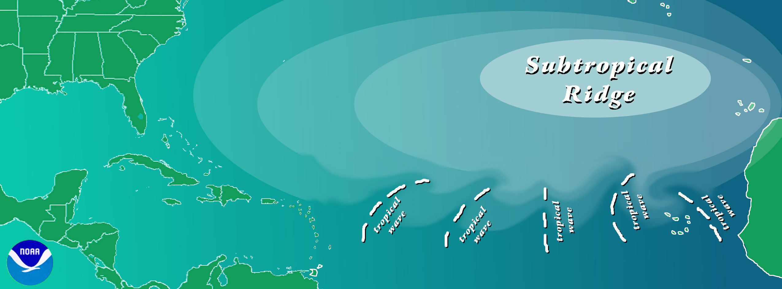
The Azores high
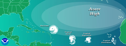
It has
been recognized since at least the 1930s that lower part of
the atmosphere (from the ocean surface to about 3 miles) westward
travelling disturbances often serve as the "seedling" circulations for
a large proportion of tropical cyclones over the North Atlantic Ocean.
These disturbances, now known as African easterly waves, had their
origins over the North African coast.
A very important ingredient is the co-called African easterly jet. This
jet arises as the result of temperature difference between the
extremely warmth over the Saharan Desert and the substantially lower
temperatures along the Gulf of Guinea coast.
 When these
two air masses meet, the atmosphere will become very unstable and (very
heavy) thunderstorms, with areas of low pressure, develop. These storms
and lows travel west with the trade wind flow across the Atlantic
Ocean. They are first seen usually in April or May and continue until
October or November. When the conditions, as described above, are
there; a hurricane is born. But, thankfully, most of these
thunderstorms will die out and never reach the hurricane-stage. On
average, about 60 storms and lows are generated over North Africa each
year, but it appears that the number that is formed has no relationship
to how much tropical cyclone activity there is over the Atlantic each
year. When these
two air masses meet, the atmosphere will become very unstable and (very
heavy) thunderstorms, with areas of low pressure, develop. These storms
and lows travel west with the trade wind flow across the Atlantic
Ocean. They are first seen usually in April or May and continue until
October or November. When the conditions, as described above, are
there; a hurricane is born. But, thankfully, most of these
thunderstorms will die out and never reach the hurricane-stage. On
average, about 60 storms and lows are generated over North Africa each
year, but it appears that the number that is formed has no relationship
to how much tropical cyclone activity there is over the Atlantic each
year.
While
only about 60% of the Atlantic tropical storms and minor hurricanes
originate from these African thunderstorms and lows, nearly 85% of the
intense (or major) hurricanes have their origins as a severe
thunderstorm. It is even suggested, though, that nearly all
of the tropical cyclones that occur in the Eastern Pacific Ocean can
also be traced back to Africa.
It is
currently completely unknown how those easterly thunderstorms change
from year to year in both intensity and location and how these might
relate to the activity in the Atlantic (and East Pacific).
El Niño and Hurricanes
Does El
Niño (a sudden rise of seawater temperature in the east-Pacific, before
the Peruvian coast) affect hurricanes?
Its likely that the answer is "yes". Of course one autumn will bring
more and more severe hurricanes than another autumn. For example in
1997 the Caribbean got seven tropical storms but only three grew out to
hurricanes. This small amount of hurricanes was certainly due to a very
strong El Niño during that year.
El Niño
changes the jet streams, a strong westerly at about 30.000 feet. During
a strong El Niño the jet stream grows stronger and moves
somewhat southwards to the Caribbean. So at higher altitudes the winds
become stronger than normal, and the huge towering complexes of clouds,
which normally accompanies and reinforces a hurricane are blown to
pieces; with the result that the storm dies out.
The year
1997 was a strong El Niño-year, followed by two La Niña-years (1998 en
1999). During a La Niña the Peruvian Seawater is colder than
normal. This had a immediate impact on hurricane activity; eight
visited the Caribbean and the American south-east coast; whereby Mitch,
end of October 1998, was the strongest and most devastating
hurricane ever; reaching class 5.
The El Niño effects at the American West coast is reverse. During an El
Niño year the coast will be visited by more hurricanes.
But not only El Niño influences the amount of hurricanes in the
Caribbean. There is also a connection with the weather in Western
Africa, the Sahel. The rain- and thunderstorms in that area are a
source for lows. These lows can produce tropical storms and eventual
hurricanes, as explained above.
Hurricane names
The WMO (World Meteorological Organization) has redacted
a list of names that will be used for coming hurricanes. In the past it
was already usual to name a hurricane after the saint of the
day at which the storm brought destruction and terror to a country.
Like in 1825 on the 26th of July Puerto Rico was visited by Santa Ana.
During the 20th century hurricanes were named after the latitude and
longitude, but that appeared to be very confusing.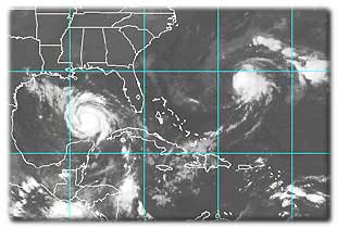
During the WO II meteorologists started with names in alphabetical
order, the first storm of the season started with an "A", the
second a "B', etc.
Eventually in 1970 the American Hurricane Centre came with a list of
names, that were repeated every 10 years. The Director choose the names
of the women in his family.
This leaded to protests from feministic organizations and in 1979 the
names were altered male and female.
At the moment the WMO has a list of names for tropical
depressions, when the wind reaches force 8 Beaufort, for the coming six
years. These names will be repeated, except for the names which
eventually where devastating. These names won't be used anymore.
Warnings
Meteorologists can rather accurately
calculate the track a hurricane will follow.
The threatened population of an area can be warned and evacuated in
time.
Especially the Hurricane Centres in the United States are very
specialized in this part of meteorology. And due to them, the number of
victims is strongly reduced during the last decennia.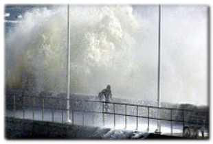
The hurricane-prone area is intensively scanned
with scouting planes; but also buoys at sea, or data from satellites
and radar are available for calculations.
Only area's with very bad communication and
living-conditions, like Central America and Bangladesh, for example,
can severely suffer under tropical cyclones.
And many lives are lost again and again.
Why don't we try to destroy
tropical cyclones?
By
using silver iodide:
Actually for a couple decades NOAA and its predecessor tried to weaken
hurricanes by dropping silver
iodide - a substance that serves as a effective ice
nuclei - into the rain bands of the storms. The idea was that the
silver iodide would enhance the thunderstorms of the rain band by
causing the super cooled water to freeze, thus liberating the latent
heat of fusion and helping the rain band to grow at the expense of the
eye wall. With a weakened convergence to the eye wall, the strong inner
core winds would also weaken quite a bit. Neat idea, but it, in the
end, had a fatal flaw: there just isn't much super cooled water
available in hurricane convection - the buoyancy is fairly small and
the updrafts correspondingly small compared to the type one would
observe in mid-latitude continental super or multi-cells. The few times
that they did seed and saw a reduction in intensity was undoubtedly due
to what is now called "concentric eyewall cycles".
A substance
on the ocean surface:
As for the other ideas, there has been some experimental work in trying
to develop a liquid that when placed over the ocean surface would
prevent evaporation from occurring. If this worked in the tropical
cyclone environment, it would probably have a detrimental effect on the
intensity of the storm as it needs huge amounts of oceanic evaporation
to continue to maintain its intensity However, finding a
substance that would be able to stay together in the rough seas of a
tropical cyclone proved to be the downfall of this idea.
Nuking them:
Lastly, there always appears ideas during the hurricane season that one
should simply use nuclear weapons to try and destroy the storms. Apart
from the concern that this might not even alter the storm, this
approach neglects the problem that the released radioactive fallout
would fairly quickly move with the trade winds over land.
Needless to say, this is not a good idea.
By etc:
Perhaps the best solution is not to try to alter or destroy the
tropical cyclones, but just learn to co-exist better with them. Since
we know that coastal regions are vulnerable to the storms, enforce
building codes that can have houses stand up to the force of the
tropical cyclones. Also the people that choose to live in these
locations should willing to shoulder a fair portion of the costs in
terms of property insurance - not exorbitant rates, but ones which
truly reflect the risk of living in a vulnerable region.
Last but not least
the SCALE
Hurricanes can be classified. The scale
that is often used is from Saffir-Simpson, as given below. To give an
indication: the most devastating hurricane, Mitch, October 1998, was a
class 5 hurricane.
|
SAFFIR-SIMPSON SCALE
|
|
Scale
NR
|
Central
Pressure
|
Winds
MPH
|
Surge
FT
|
Damage
|
|
1
|
>28.94" (>980mb)
|
74-95
|
4-5
|
Minimal
|
|
2
|
28.91-28.50" (979-965mb)
|
96-110
|
6-8
|
Moderate
|
|
3
|
28.47-27.91" (964-945mb)
|
111-130
|
9-12
|
Extensive
|
|
4
|
27.88-27.17" (944-920mb)
|
131-155
|
13-18
|
Extreme
|
|
5
|
<27.17" (<920mb)
|
>155
|
>18
|
Catastrophic
|
Photo's from NOAA; National Hurricane Centre
With thanks to: www.NOAA.com
Mail to: wijke@scribeweekly.com
Archive of Scribeweekly
Weather Specials
|
